Creator Record
Metadata
Name |
Richter, Wilmer S. |
Notes |
Wilmer Siegfried Richter (1891-1993) was a commercial artist. He lived on Pennsylvania Avenue in Haverford Township, Delaware County. Pa.. from 1919 to the early 1960s. He did magazine illustrations for Colliers, McCalls, Ladies Home Journal and others. He was later on-staff at a business magazine and taught oil painting. In 1963 he donated many charcoal drawings of historical locations in the area to the Haverford Township Historical Society. By 1973 he had moved to Sarasota, Florida. |
Related Records
-
Drawing - Abandoned Quarry on Cobb's Creek Rd. Near Haverford Rd. (1933)
Sketch, charcoal, 12" h x 18" w on a 16" x 20" mat. Description on front in pencil by artist reads "Abandoned Quarry on Cobb's Creek Rd. near Haverford Rd." Printed label on mat adds "A54" and "Razed." The tall timber structure was on the east side of present-day Karakung Drive, near its north end. *NOT TO BE COPIED OR SOLD*
Record Type: Object
-
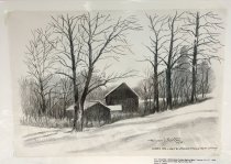
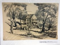
Drawing - Addingham [#1] (1927)
Sketch, charcoal, 14 1/2" h x 11" w on 18 1/2" x 13" mat. Description on front by artist reads "Copy from Watercolor 1927." Printed label on mat adds "A35 Addingham." Drawing looks down on closely clustered buildings; low one in front has ladder propped up to sloping flat roof. "NOT TO BE COPIED OR SOLD*
Record Type: Object
![Addingham [#1] (1927)](https://s3.amazonaws.com/pastperfectonline/images/museum_436/009/thumbs/19830221.jpg)
-
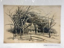
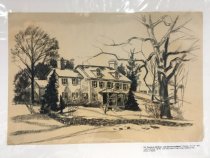
Drawing - Addingham [#2] (1930)
Drawing, charcoal, 12" h x 17 1/4" w on 16" x 20" mat. Description on printed label on mat reads "A40" and "Addingham - Charcoal from color slide (house still exists)." *NOT TO BE COPIED OR SOLD*
Record Type: Object
![Addingham [#2] (1930)](https://s3.amazonaws.com/pastperfectonline/images/museum_436/009/thumbs/19830201.jpg)
-
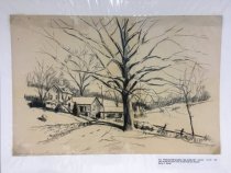
Drawing - Addingham [#3] (1932)
Drawing, charcoal, 12" h x 18" w on 16" x 20" mat. Description on front by artist reads "Addingham." Printed label on mat adds "A37" and "Addingham - mills along Darby Creek, charcoal from watercolor." *NOT TO BE COPIED OR SOLD*
Record Type: Object
![Addingham [#3] (1932)](https://s3.amazonaws.com/pastperfectonline/images/museum_436/009/thumbs/19830223.jpg)
-
Drawing - Addingham [#5] (1939)
Sketch, charcoal, 11" h x 17" w on 14" x 20" mat. Description on front by artist reads "From 1939 w/c [watercolor]" Printed label on mat adds "A39" and "1939 Addingham - charcoal from watercolor." *NOT TO BE COPIED OR SOLD*
Record Type: Object
![Addingham [#5] (1939)](https://s3.amazonaws.com/pastperfectonline/images/museum_436/009/thumbs/19830225.jpg)
-
Drawing - Addingham [#6] (late 1930s)
Drawing, charcoal, 12" h x 17 1/4" w on 16" x 20" mat. Description on front by artist reads "Addingham." Printed label on mat adds "A41," "late 1930's" and "Addingham - charcoal from color slide." *NOT TO BE COPIED OR SOLD*
Record Type: Object
![Addingham [#6] (late 1930s)](https://s3.amazonaws.com/pastperfectonline/images/museum_436/009/thumbs/19830226.jpg)
-
Drawing - Addingham [#7] (late 1930s)
Sketch, charcoal, 12" h x 17 1/4" w on 16" x 20" mat. Description on front by artist reads "Addingham". Printed label on mat adds "A42" and "Addingham - charcoal from color slide." *NOT TO BE COPIED OR SOLD*
Record Type: Object
![Addingham [#7] (late 1930s)](https://s3.amazonaws.com/pastperfectonline/images/museum_436/009/thumbs/19830227.jpg)
-
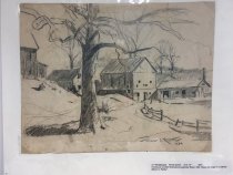
Drawing - Addingham, Del. Co. (1928)
Drawing, charcoal with yellow shading, 21" h x 17" w on 24" x 20" mat. Description on front by artist reads "Addingham, Del. Co. 1928." Printed label on mat adds "A60" and "Charcoal copy of watercolor." (Note: Addingham is an area along the east side of Darby Creek in the vicinity of Garrett Road and Rosemont Avenue in Upper Darby Township, Delaware County, Pa.) *NOT TO BE COPIED OR SOLD.*
Record Type: Object
-
Drawing - Addingham, Del. Co. Pa. (1928)
Sketch, charcoal, 15" h x 11" w on 17" x 13" mat. Description by artist on front reads "Addingham, Del. Co. Pa." Printed label on mat adds "A36" and "1928." *NOT TO BE COPIED OR SOLD*
Record Type: Object
-
Drawing - Along Cobb's Creek between Manoa Rd. and City Line (1927)
Sketch, charcoal, 12" h x 18" w on 16" x 20" mat. Description on front in pencil by artist reads "D - Along Cobb's Creek between Manoa Rd. and City Line." 1927. Printed label on mat adds "A52" and "Buildings along Cobb's Creek" and "Now razed." (This scene was between Manoa Road and Township Line Road (City Line Avenue) in Haverford Township. These buildings no longer exist.) *NOT TO BE COPIED OR SOLD*
Record Type: Object
-
Drawing - Behind Barn on the West Bank of the Creek near Penfield Station" (1928)
Drawing, charcoal, 12" h x 17" w on 14" x 18" mat. Description on front by artist in pencil reads "[unintelligible] behind barn on the west bank of the creek near Penfield Station" Dated 1928. Printed label on mat adds "A22" and "Barn near Manoa Road ..." (Note: Penfield Station is on the Philadelphia and Western Railroad line, later the SEPTA Norristown High Speed Line.) *NOT TO BE SOLD OR COPIED*
Record Type: Object
-
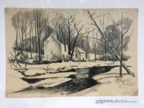
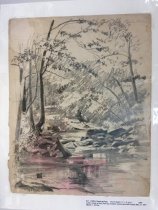
Drawing - Bend in the Creek, The (1925)
Drawing, charcoal, 12" h x 17" w on 15" x 20" mat. Description on front in pencil by artist reads "The bend in the creek where we brought the children to throw stones and fall in." Dated 1925. Printed label on mat adds "A18" and "Darby Creek at the bend about 1/2 mile north of Lawrence Road." *NOT TO BE SOLD OR COPIED*
Record Type: Object
-
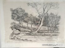
Drawing - Cobb's Creek at Ford (1942)
Sketch, pencil 11 1/4" w x 14 1/4" h on 13" x 17" mat. No artist signature, date or description on front. Printed label on mat reads "A31 Cobb's Creek at Ford Pencil Sketch 11 1/4" X 14 1/4" 1942 / Cobb's Creek at ford (half way between Manoa and Mill Roads) May 31, 1942 / Wilmer S. Richter." (Shows view upstream along creek with rocks in water.) *NOT TO BE SOLD OR COPIED*
Record Type: Object
-
Drawing - Creek Rd - White Streak Trolley Right of Way (1928)
Sketch, charcoal, 12" h x 17" w on 13 1/2" x 20" mat. Description on front by artist reads "Creek Rd - White Streak Trolly [sic] Right of Way." Printed label on mat adds "A23" and "Barn." Image shows two outbuildings on a hillside among trees. *NOT TO BE COPIED OR SOLD*
Record Type: Object
-
Drawing - Ellis Road in back of St. Georges Church (1929)
Sketch, charcoal 12" h x 18" w, mounted on 16" x 22" mat. Description on front in pencil by artist reads "Ellis Rd. in back of Saint Georges Church." Printed label on mat adds "A58." *NOT TO BE COPIED OR SOLD*
Record Type: Object
-
Drawing - Farm and Old Sycamore Tree on Ellis Rd. near Railroad (1931)
Sketch, charcoal 12" w x 18" h, mounted on 16" x 20" mat. Description on front in pencil by artist reads "Farm and Old Sycamore Tree on Ellis Rd. near Railroad." Printed label on mat adds "A56." *NOT TO BE COPIED OR SOLD*
Record Type: Object
-
Drawing - Farmhouse (1924)
Sketch, pencil, 10" h x 13" w on 13" x 16" mat. Signed and dated by artist, but without a description. Printed label on mat reads "A17 Farmhouse Pencil Sketch 10 x 13" 1924 / Farmhouse on Ellis Road above Lawrence Road, 1924, House no longer in existence." *NOT TO BE SOLD OR COPIED*
Record Type: Object
-
Drawing - House on Cobb's Creek Rd. Next to Quarry (1933)
Sketch, charcoal, 12" h x 18" w on a 16" x 20" mat. Description on front in pencil by artist reads "B - House on Cobb's Creek Rd. next to Quarry." Printed label on mat adds "A55" and "Home on Karakung Drive, south of intersection of Haverford Rd. Building, with additions, still standing 1968" (Note: Across from Karakung Swim Club parking lot, up on the hill.) *NOT TO BE COPIED OR SOLD*
Record Type: Object
-
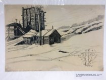
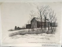
Drawing - House on Mill Road - Near Beechwood Station (1937)
Sketch, charcoal, 12" h x 18" w on 16" x 21" mat. Description on front in pencil by artist reads "House on Mill Road - Near Beechwood Station." Printed label on mat adds "A59" and "Leedom Mansion - Mill Rd., north side, west of Cobb's Creek, Haverford Twp." Later note: "Miller - Dickinson - Leedom Mansion, renovated by Albert Baker between 1947 and 1960." *NOT TO BE COPIED OR SOLD*
Record Type: Object
-
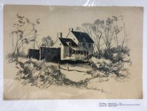
Drawing - House on Right - Lawrence Rd. - Now Flintlock (1940)
Sketch, charcoal, 12" h x 18" w on 16" x 20" mat. Description on front in pencil by artist reads"D - Old House on Right - Lawrence Rd. Now Flintlock." 1940. Printed label on mat adds "A53" and "North side of Lawrence Rd. east of Ellis Rd., Haverford Township." (Note: This house, with its later additions, is still standing and is the Lawrence Farm house on the north side of Lawrence Road.) *NOT TO BE COPIED OR SOLD*
Record Type: Object